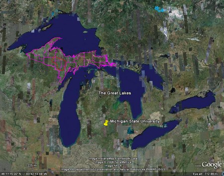
Shapefiles in Google Earth

Last week I put together a presentation about our Michigan UP Ecological-Economic Modeling project for our funding body. I thought it would be useful to demonstrate the location of our study area in Google Earth, so I set about learning how to import ESRI shapefiles into Google Earth. I discovered it's really easy.
My first stop in working this out was 'Free Geography Tools' and their series of posts about exporting shapefiles to Google Earth. From their list of free programs, first I tried Shp2KML by Jacob Reimers. Unfortunately this program resulted in some security conflicts with our network so I couldn't use it. Next I tried a second program, also called shp2kml, from Zonum Solutions and that worked a treat. Zonum have several other Google Earth tools that I'll have to try out sometime.
You can download the kml file it produced for the boundary of our study area here (right click, 'save as' or whatever). If you have Google Earth installed you can then just double click that file (once downloaded) and Google Earth will take you right there. When I first created the link above, I hoped that when you clicked on it the file would open automatically in Google Earth - it didn't. But after a little playing I found that kmz files will open automatically in Google Earth. kmz files are simply zipped (compressed) kml files - I used WinRar to zip the kml file and then changed the file suffix from zip to kmz. Click here - the study area file will open automatically in Google Earth (from Firefox at least - see note below). Sweet.
I also exported shapefiles for DNR and private industrial stand boundaries which match up nicely with spatial patterns of vegetation observed in the landscape. Obviously, I can't post these shapefiles online, but you can see evidence of land ownership boundaries in our study area right here. The light green rectangular area is non-DNR land and has been clear cut. The surrounding area is managed by the DNR (possibly selective timber harvest) - the resulting land cover from different management approaches is stark. These are the sorts of patterns and issues we will be able to examine using our ecological-economic landscape model.
[Note - When posting the presentation to our web server I also learned about MS Internet Explorer .png issues. They say they've fixed them, but there still seem to be some problems - try viewing this page in both IE and Firefox and note the difference (hover your cursor over the words at the bottom). Viewing the presentation pages in Firefox means the links to the .kmz files are active - they are not in IE. The issue arose becasue I used OpenOffice Impress to convert my MS PowerPoint file to html files.]
Labels: Computing, MichiganUP, Web

This work by James D.A. Millington is licensed under a Creative Commons Attribution-Noncommercial-Share Alike 3.0 United States License.


2 Comments:
I noticed you mentioned my Shp2Kml converter. Can you please let me know which security conflicts you were experiencing?
Jacob Reimers
Jacob,
I'm afraid I don't remember the previous error message.
I have just tried to replicate the error, but to no avail. This time, the program created a .kml file that directed me to the North Pole in GoogleEarth (not where the shapefile points). I've tried this for several shapefiles, both projected and unprojected, and all result in the same North Pole adventure...
Cheers
Post a Comment
<< Home