Technically I had been to Nairobi before our last trip last month, so I replied yes when people there asked. But then I told them it was when I was two years old and they laughed about how that didn’t count – partly because I can’t remember a thing from that time and partly because the city has changed so much. Back in 1982, the population of the city was around 900,000 but today it is over 3 million, and possibly up nearer 4 million during the day as people come into the city to work.
I was in Nairobi with colleagues Bruce Malamud and Faith Taylor on an initial research trip for our work on the physical dimensions of hazards in urban areas of Africa. During a meeting on the trip at Mzuzu University near another of our study sites – Karonga in Malawi – someone asked why we were focusing on hazards in urban areas particularly. The answer is partly because of the growth exemplified by Nairobi; Africa is urbanising rapidly and estimates are that 56% of the population of African will be urban by the middle of the century.
The UrbanARK project aims to generate knowledge and build capacity to support the growing need for disaster risk reduction strategies for urban populations in sub-Saharan Africa. The component of the project is predominantly driven by a physical science perspective, building on computer simulation and other modelling, to investigate physical hazards and impacts. Our trip was really a scoping exercise to refine our methodology, and to meet local collaborators in our case study cities.
Depending on whose estimates one chooses, Nairobi today is around the 12th largest city in Africa. During our three days there - negotiating the traffic which at times can be debilitating - we met with various regional and city officials to discuss hazards experienced in the city, how they are planned for, managed and mitigated against.
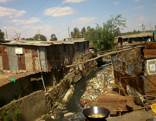
Flash flooding in the lower-lying areas of the city as water flows down from the upland areas is a primary hazard, exacerbated by informal settlements as people construct dwellings on the available space rivers and streams. Many of these areas are really slums and on one day of our trip we visited some of these areas, including Kibera, said by some to be the largest slum in Africa covering 4.5 sq km and housing more than half a million people.
A stream running through Kibera
One of the many problems in these informal settlements, and another which increases problems of flooding, is solid waste management. The researchers at the African Population and Health Research Center involved in the UrbanARK project will focus on this issue, and we saw examples of how discarded waste can block what planned (or unplanned) drainage provision exists. Understanding how these elements of physical interactions between human infrastructure and natural processes (such as overland flow) is important if such issues are to be meaningfully addressed.
Whilst in Nairobi we also visited the Kenya Red Cross to discuss hazards they help to deal with in the city and heard about their current work on fires in informal settlements. One project they are currently working on aims to install smart, web-enabled fire (heat) sensors in houses in informal settlements to provide an early warning system. Fires in informal settlements can spread quickly because of the construction materials used and the high density of buildings. These fires frequently cause loss of life and it is hoped that by creating a network of sensors able to send text message alerts to locals, fires can be more effectively dealt with and risk can be reduced.
A final stop in Nairobi before we travelled onwards to Malawi was to visit the Regional Centre for Mapping of Resources for Development to find out what sorts of spatial information is being collected and used across sub-Saharan Africa. Interestingly, while there we found out more there about data and tools for Malawi than for Kenya. For example, we discovered the newly launched Malawi Hazards and Vulnerability Atlas which looks like a very useful tool at the country-level for assessing risks from a variety of hazards. As is often the case, however, the tool does not focus specifically on urban issues, but it was useful to think about on the flight south past Mount Kilimanjaro and crossing Lake Malawi.
From Malawi’s capital Lilongwe, we immediately headed north to Mzuzu to link up with colleagues involved with UrbanARK at Mzuzu University. The Malawi case study city is not actually Mzuzu itself but the smaller town of Karonga on the shore of Lake Malawi yet further north. Before we continued to Karonga to better understand issues in the town, we discussed the most important hazards faced there - flooding, earthquakes, strong winds and lightning.
On reaching Karonga, the ways in which these hazards are manifest in the town became clearer. Karonga is much smaller than Nairobi and although it will never reach the same scale, it is expected to grow over the coming years. Currently with a population of around 50,000 (expected to grow to 72,000 by 2022), the town feels much less dense than parts of Nairobi (like Kibera). The primary means of transport in Karonga is bicycle, meaning the traffic jams experienced in Nairobi are largely absent (although driving past the market in the evening can be slower than walking as pedestrians outnumber cars by probably more than 100 to 1). Houses in town are generally made of brick and are separated by small yards, but the poverty is on a similar level to the deprived areas of our bigger case study city. As a whole Malawi is poorer compared to Kenya (GNP of $715 per capita vs $2,157) with a lower human development index (0.414 vs 0.535) and a greater proportion of the population are in multidimensional poverty (67% vs 48%).
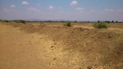
With the North Rukuru River flowing down from hills 20km to the west and forming the northern boundary of the town, flooding has been a long standing issue in Karonga. To mitigate against this, the centre of town was moved away from the lake shore in the early 1990s, meaning there is now ‘new town’ and ‘old town’ (although the more flood-prone old town is still largely populated). The remainder of Karonga is protected by an earthen dyke to the north, but the construction of a higher road embankment at the east end, combined with local removing some parts of the dyke for building materials, means that flood waters can still overtop or circumvent the dyke. We got an interesting look at the original plans for the dyke in the local planning office and walked sections of the dyke with our collaborators (tailed by a large group of local kids – we were the entertainment for the afternoon!)
The dyke at Karonga
Another issue for Karonga is the recurrence of earthquakes (or tremors), situated as it is on the Livingstone fault that forms the Great African Rift valley and Lake Malawi itself. We saw some evidence of the quake that struck in 2009, causing an uplift of the main road through town and cracks in some buildings. Other hazards we discussed with local charity organisations included strong winds and hailstorms.
On reflection, although there are clear differences between our two case study cities there are common issues. In both places, well-meaning plans that aim to reduce risks posed by physical hazards are often confounded by informal settlements that spring up wherever people can best make a living with what little they have. In both urban centres the problem of flooding in lower-lying areas arises as water flowing from upland areas inundates land on which ideally people would not be living but which by necessity (due to lack of space) or convenience (proximity to fertile soils) means that they do. Although Nairobi often felt more chaotic than Karonga, this may simply have been because the population (and motorised traffic) density is so much greater; interactions between uncoordinated actions seem to abound in both, often reinforcing and exacerbating existing risks. These issues seem to be particularly African in the context of physical hazards in urban areas.
It was over 30 years between my first two visits to Nairobi, but my next visit will likely be a lot sooner than 2045. By that year Nairobi (and Karonga) will have continued to change but hopefully for the better for the majority of people, and in ways that mitigate risks from physical hazards.
When you haven't done something for a while it's often best not to rush straight back in at the intensity you were at before. So here's a nice easy blog to get me going again (not that I was blogging intensely before!).
I didn't blog about it at the time (unsurprisingly), but back in late June 2013 I went to visit a colleague of mine in Madrid, Dr Francisco Seijo. Francisco and I met back at something I did blog about, the 2009 US-IALE conference in Snowbird. Since then we've been discussing how we can use the idea of coupled-human and natural systems to investigate Mediterranean landscapes.
Example of Traditional Fire Knowledge. The ‘pile-burning’ technique involves raking, piling and igniting leaves. This contrasts with ‘a manta’ broadcast burning in which leaves and ground litter are burned across larger areas. Photos by the authors of the paper.
After a brief field visit by me, an interview campaign by Francisco, collection of secondary data from other sources (aerial photography and official fire statistics) and some desk analysis, we recently published our first paper on the work. Entitled Forgetting fire: Traditional fire knowledge in two chestnut forest ecosystems of the Iberian Peninsula and its implications for European fire management policy, and published in the journal Land Use Policy, the article presents the results of our mixed-methods and interdisciplinary approach. Building on Francisco's previous examination of 'pre-industrial anthropogenic fire regimes' we to to investigate differences between the fire regimes and management approaches of chestnut forest ecosystems in two municipalities in central Spain. In the paper we also discuss ideas of Traditional Ecological Knowledge (TEK), the related idea of Traditional Fire Knowledge (TFK), and discuss them in light of contemporary fire management approaches in Europe.
The full abstract is below with links to the paper. I'll stop here now as this rate of blogging it making me quite dizzy (but hopefully I'll be back for more soon).
----
Seijo, Francisco, James DA Millington, Robert Gray, Verónica Sanz, Jorge Lozano, Francisco García-Serrano, Gabriel Sangüesa-Barreda, and Jesús Julio Camarero (2015) Forgetting fire: Traditional fire knowledge in two chestnut forest ecosystems of the Iberian Peninsula and its implications for European fire management policy. Land Use Policy47 130-144. doi: 10.1016/j.landusepol.2015.03.006
[Online] [Pre-print]
Abstract
Human beings
have used fire as an ecosystem management tool for thousands of years. In the
context of the scientific and policy debate surrounding potential climate
change adaptation and mitigation strategies, the importance of the impact of
relatively recent state fire exclusion policies on fire regimes has been
debated. To provide empirical evidence to this ongoing debate we examine the
impacts of state fire exclusion policies in the chestnut forest ecosystems of
two geographically neighbouring municipalities in central Spain, Casillas and
Rozas de Puerto Real. Extending the concept of ‘Traditional Ecological
Knowledge’ to include the use of fire as a management tool as ‘Traditional Fire
Knowledge’ (TFK), we take a mixed-methods and interdisciplinary approach to
argue that currently observed differences between the municipalities are useful
for considering the characteristics of “pre-industrial anthropogenic fire
regimes” and their impact on chestnut forest ecosystems. We do this by
examining how responses from interviews and questionnaire surveys of local
inhabitants about TFK in the past and present correspond to the current
biophysical landscape state and recent fire activity (based on data from
dendrochronological analysis, aerial photography and official fire statistics).
We then discuss the broader implications of TFK decline for future fire
management policies across Europe particularly in light of the published
results of the EU sponsored FIRE PARADOX research project. In locations where
TFK-based “pre-industrial anthropogenic fire regimes” still exist, ecosystem
management strategies for adaptation and mitigation to climate change could be
conceivably implemented at a minimal economic and political cost to the state
by local communities that have both the TFK and the adequate social, economic
and cultural incentives to use it.
Key words
Fire exclusion policies; traditional ecological knowledge; traditional
fire knowledge; Chestnut forest ecosystems; FIRE PARADOX
I spent a couple of weeks this month in Morocco, the majority of which was scouting out a route for a new physical geography fieldtrip for second year undergraduates at King's College London. For the last several years the physical geography fieldtrip has been based on the Morocco coast at Agadir and Essaouira, visiting nearby sites. The new fieldtrip will take more of a transect approach, starting in Marrakech, traversing the High Atlas mountains and following the River Draa out to the edge of the Sahara (see map below).
As we work our way up and through the High Atlas one of the things we'll consider is how vegetation changes and what might be driving those changes. In the picture below you can see colleagues on the trip Prof. Drake and Dr Chadwick (@DrMChad) debating (and betting on!) vegetation on the hills over-looking the town of Demnate.
For example, what are the relative influences of climate and human activity on the vegetation we see? In the picture below Prof Drake confronts one potential disturbance.
As this is a new trip and we'll be staying in a new location each night, one of our tasks was to check the accommodation we'll be staying in. Here hotel connoisseurs Drake and Chadwick relax in luxury in the gîte at Toufghine.
There's some impressive geology in the High Atlas and we'll discuss that as we go too. The scale of some of the tectonic features is illustrated by Prof Drake in the bottom right of the picture below.
We'll also be surveying rivers, both their geomorphology and ecology. Another of our tasks therefore was to work out what we would examine and where along the various rivers in the region.
Once we get over the High Atlas and the Anti-Atlas beyond we'll follow the River Draa all the way to the desert. The Draa is a vital life-line for people in the region, with water drawn from the river used to irrigate agriculture (including wheat).
Once the water has all been used up we reach the desert. There we'll look for evidence of previous flows of the Draa and of climate change. Some of the dunes can be steep.
But the view from the top is usually good, especially at sunset. We'll stay a night out in the dunes with the students to get a feel for what it might be like living in such hostile environment.
And of course there will be camels! Below, our driver negotiates a herd as we head back north to Marrakech on the final leg of our trip.
So it looks like we're going to have a great trip with our students in December and following years! The trip will allow us to investigate how climate, geology, geomorphology, ecology and livelihoods change across space and how they have changed through time.
Standardised and transparent model descriptions for agent-based models
Last month saw initial publication (although officially it is a May publication!) of the paper that came out of the agent-based modelling workshop in which I participated at iEMSs 2014.
Birgit Müller put in some great work to summarise our discussion and bring together the paper which addresses how we describe agent-based models. Standardised and transparent model descriptions for agent-based models: Current status and prospects has several highlights:
We describe how agent-based models can be documented with different types of model descriptions.
We differentiate eight purposes for which model descriptions are used.
We evaluate the different description types on their utility for the different purposes.
We conclude that no single description type alone can fulfil all purposes simultaneously.
We suggest a minimum standard by combining particular description types.
To present our assessment on how well different purposes are met by alternative description types we produced the figure below. In the figure light grey indicates limited ability, medium grey indicates medium ability and dark grey high ability (an x indicates not applicable). Full details of this assessment are presented in the version of the diagram presented in an online supporting appendix.
Citation and abstract for the paper below. Any questions, or for a reprint, get in touch.
Müller, B., Balbi, S., Buchmann, C.M., de Sousa, L., Dressler, G., Groeneveld, J., Klassert, C.J., Quang Bao Le, Millington, J.D.A., Nolzen, H., Parker, D.C., Polhill, J.G., Schlüter, M., Schulze, J., Schwarz, N., Sun, Z., Taillandier, P. and Weise, H. (2014). Standardised and transparent model descriptions for agent-based models: Current status and prospects. Environmental Modelling & Software, 55, 156-163.
Abstract
Agent-based models are helpful to investigate complex dynamics in coupled human–natural systems. However, model assessment, model comparison and replication are hampered to a large extent by a lack of transparency and comprehensibility in model descriptions. In this article we address the question of whether an ideal standard for describing models exists. We first suggest a classification for structuring types of model descriptions. Secondly, we differentiate purposes for which model descriptions are important. Thirdly, we review the types of model descriptions and evaluate each on their utility for the purposes. Our evaluation finds that the choice of the appropriate model description type is purpose-dependent and that no single description type alone can fulfil all requirements simultaneously. However, we suggest a minimum standard of model description for good modelling practice, namely the provision of source code and an accessible natural language description, and argue for the development of a common standard.
Keywords
Agent-based modelling; Domain specific languages; Graphical representations; Model communication; Model comparison; Model development; Model design; Model replication; Standardised protocols
#ialeuk2014 - Urban landscape ecology: Science, policy and practice
Something else to keep me busy this year is the organisation of the Annual Conference of the International Association for Landscape Ecology (UK). We'll be hosting the conference at King's in central London on 1-3 September 2014. We will be having two days of presentations on science, policy, planning and practice, networking events and workshops. We're still planning them, but we're hoping that fieldtrips on the final day will include visits to the Thames Barrier and surrounding area and to the top of the Shard, Western Europe’s tallest building.
The theme of the conference this year is 'Urban landscape ecology: science, policy and practice’. We are keen to hear from researchers, policymakers, and practitioners developing new evidence, policies, strategies, plans or projects on the ground that relate to the landscape ecology of urban and peri-urban areas. The call for abstracts has just gone out; please submit abstracts (300 words) for presentations and posters to conference2014@iale.org.uk by 28 February 2014. We expect selected papers will compose an edited volume on current key issues in urban landscape ecology. The full call for abstracts is copied below.
We'll be updating the conference website regularly throughout the year as conference planning continues, so keep checking back at: http://iale.org.uk/conference2014 Further details of the conference programme and how to register will be available there soon. We'll be using the hashtag #ialeuk2014 so please use this on social media. And any questions or queries, don't hesitate to get in touch via conference2014@iale.org.uk
---------------------------------------------------- Call for Abstracts - Urban landscape ecology: Science, policy and practice
Cities are growing rapidly. Across Europe, more than 70 per cent of people already live in urban areas, including 80 per cent of the UK population. The growth of cities poses ever-increasing challenges for the natural environment on which they impact and depend, not only within their boundaries but also in surrounding peri-urban areas. Landscape ecology – the study of interactions across space and time between the structure and function of physical, biological and cultural components of landscapes – has a pivotal role to play in identifying sustainable solutions.
This conference will consider how concepts from landscape ecology can inform the maintenance and restoration of healthy, properly functioning natural environments across urban and peri-urban landscapes, as the foundation of sustained economic growth, prospering communities and personal wellbeing.
Conference themes are likely to include: ecological connectivity of terrestrial and aquatic environments; ecosystem services, including regulation of air quality, urban heat, and water quality and quantity, as well as cultural services; planning for change; and landscape-scale management of terrestrial and aquatic ecosystems.
We are keen to hear from researchers, policymakers, and practitioners developing new evidence, policies, strategies, plans or projects on the ground that relate to the landscape ecology of urban and peri-urban areas.
Please submit abstracts (300 words) for presentations and posters to conference2014@iale.org.uk by 28 February 2014. Selected papers will compose an edited volume on current key issues in urban landscape ecology.
There will be two days of presentations on science, policy, planning and practice, networking events and workshops. We are hoping that fieldtrips on the final day will include visits to the Thames Barrier and surrounding area and to the top of the Shard, Western Europe’s tallest building, from where we can consider connectivity across London and beyond.
Further details of the conference programme and how to register will be available soon.
This week I received my copy of 'Patterns of Land Degradation in Drylands: Understanding Self-Organised Ecogeomorphic Systems' which I contributed to after participating at a workshop in Potsdam, Germany. It's a well produced book and as I was flicking through it I came across one of the pieces I wrote. Rather than just leave it hidden away on pages 60 - 61 in the book I thought I'd reproduce it here. It's less than 500 words and to the point. Just right for a blog post.
"In science, patterns are observations of any non-random structure. In ecology for example, a pattern has long been understood as the “structure which results from the distributions of organisms in, or from, their interactions with their environments” (Hutchinson 1953, p.3, also see Watt 1947, Greig-Smith 1979). However, when identifying patterns in nature, scientists more precisely mean the identification of patterns in data about nature. Important considerations for identifying patterns, therefore, are the means by which data were collected, and most importantly the scales of measurement used to collect data. In particular, two components of scale – grain and extent – are important in determining whether a pattern is identified. Grain is the resolution of measurement (i.e. the smallest unit of measurement at which objects or states can be distinguished), whereas extent is the full scope of observation or total range over which measurements are made. As examples, different spatial patterns will be detectable in maps of vegetation configuration in semi-arid areas depending on the grain and extent of the maps (e.g. compare Figures 3 and 6 in Barbier et al. 2006), and different temporal patterns will be detectable in storm hydrographs depending on the resolution and duration of measurement (e.g. compare drainage for 10 minute intervals with full 80 minute duration, and observed drainage with simulated drainage, in Figure 5 of Mueller et al. 2007). In other circumstances, observed structures may be described as being ‘scale-free’. These structures lack a characteristic length scale and have the same properties across any grain and extent of measurement (e.g. power-law distributions of vegetation patch sizes; Kéfi et al. 2007). These scale-free structures can also be considered to be patterns.
Because patterns are non-random, they have the potential to provide information. In natural science this information is usually understood as being about the processes that caused the pattern. Thus, identifying patterns is useful because they can be used to investigate processes (Levin 1992). Processes are typically assumed to act at a different scale from the patterns they produce, with patterns either emerging from processes at smaller scales (‘bottom-up’ processes) or imposed by constraints at larger scales (‘top-down’ processes). It is also important to consider the reciprocal effects of patterns on processes (Turner 1989). For example, the field of landscape ecology has placed an emphasis on the quantification of spatial pattern using pattern metrics (e.g. McGarigal 2006) and shown how the history of previous ecological processes can increase the strength and extent of spatial pattern (Peterson 2002). The ‘pattern-oriented modelling’ (POM) approach has been developed to use models to help decode the information present in patterns to better understand processes (Wiegand et al. 2003, Grimm et al. 2005). The POM approach iteratively compares empirical and model-output patterns at multiple scales and levels of organization and for multiple models to identify most appropriate models. Approaches like POM, which place pattern at the centre of scientific investigation, are vital for improving understanding about physical processes."
References
Barbier N, Couteron P, Lejoly J et al (2006) Self-organized vegetation patterning as a fingerprint of climate and human impact on semi-arid ecosystems. J of Ecol 94:537-547
Greig-Smith P (1979) Pattern in vegetation. J of Ecol 67: 755-779
Grimm V, Revilla E, Berger U et al. (2005) Pattern-oriented modeling of agent-based complex systems: Lessons from ecology. Science 310:987-991
Hutchinson GE (1953) The concept of pattern in ecology. Proc of the Acad of Nat Sci of Philadelphia 105:1-12
Kéfi S, Rietkerk M, Alados, CL et al (2007) Spatial vegetation patterns and imminent desertification in Mediterranean arid ecosystems. Nature 449:213-217
Levin SA (1992) The problem of pattern and scale in ecology: The Robert H. MacArthur award lecture. Ecology 73(6):1943-1967
McGarigal K (2006) Landscape pattern metrics. In: El-Shaarawi AH and Piegorsch WW (eds) Encyclopedia of Environmetrics. Wiley: Chichester, UK
Mueller EN, Wainright J, Parsons, AJ (2007) Impact of connectivity on the modeling of overland flow within semiarid shrubland environments. Water Res Res 43:W09412
Peterson GD (2002) Contagious disturbance, ecological memory, and the emergence of landscape pattern. Ecosystems 5:329-338
Turner MG (1989) Landscape ecology: The effect of pattern on process. Ann Rev of Ecol and Syst 20:171-197
Watt, AS (1947) Pattern and process in the plant community. J of Ecol 35:1-22
Wiegand T, Jeltsch F, Hanski I et al (2003) Using pattern-oriented modeling for revealing hidden information: A key for reconciling ecological theory and application. Oikos 100:209-222
Citation
Jeltsch, F., Millington, J.D.A., et al. (2014) Resilience, self-organization, complexity and pattern formation In: Mueller, E.N., Wainwright, J., Parsons, A.J. and Turnbull, L. (Eds.) Patterns of Land Degradation in Drylands. Springer, pp. 55-84.
Just this week our first year undergraduates had their fieldweek, with lots of geography-related activities across London. For the physical geography activities we headed up to Heartwood Forest, the largest new native forest in England (near Sandridge in Hertfordshire). A nice video from last year's trip is below.
As you can see from the video, currently much of the 'forest' looks more like fields than what would be considered forest in Michigan, but the 600,000 trees being planted by volunteers will grow over the coming years to change that. There are three existing ancient woodlands (covering 45 acres) in the entire 858 acre (347 ha) area the Woodland Trust have acquired. Much of this area was previously agricultural land - the planted trees and newly created meadows will connect the existing woodland.
So there's going to be some big ecological changes over the coming years as landscape changes. To keep track of changes in vegetation and animal populations volunteers from the Herefordshire Natural History Society (HNHS) have set up a monitoring group that regularly collect data on the growth of new trees, plants, mammals, birds and butterflies.
Similarly, some of the activities our first year undergrads undertook were to do ecological surveys of understory and overstory vegetation. Our students also did hillslope surveys and soil moisture monitoring, measured vertical wind speed profiles (to see how wind speed changes with height from the ground), explored the use of helium balloons and thermal cameras to make aerial photographs and other observations, and learned how to use global positioning system (GPS) units. The students seemed to enjoy the day at Heartwood, and the entire fieldweek for that matter, as you can see from their activities on Twitter (we use the #kclfield hastag to associate tweets with our field activities).
Over the coming years we hope to expand our students' field activities at Heartwood to our third year undergraduate and taught Master's students. In particular, we hope that dissertation research by these students will be able to contribute to the efforts of the Heartwood monitoring group, to collect data and investigate questions of ecological interest. For example, to analyse presence/absence data for mammals like woodmice, we might use statistical modelling techniques like those I used to examine neotropical bird populations in Michigan.
It's going to be very interesting watching and studying the ecological changes as Heartwood really does become a forest over the years. Keep track of the changes by visiting the forest yourself or via the HSNS website, the Heartwood blog and right here on this blog.
Things got a bit crazy this month as I made the transition from my Leverhulme Fellowship to a permanent position at King's as Lecturer in Physical and Quantitative Geography. I'm now Programme Director on the MSc in Environmental Monitoring, Modelling and Management (which I completed 10 years ago this month!) and preparing for of new modules on which I'm teaching this term has kept me busy. Specifically, this term I'm teaching on the postgraduate module 'Methods for Environmental Research' and the undergraduate modules 'Principles of Geographical Inquiry II' and 'Current Research in... Ecosystem Services' (which I taught last year also). So it's been busy, but also stimulating to be putting thought into how best to communicate and illuminate ideas.
As part of the Intro for our new postgraduate students, and so that can find out more about the research that we do in the department, this week the Earth and Environmental Dynamics research group seminar series was given over to several short presentations by members of staff. The slides from mine is below.
Next month I'll give a summary of the work I did during my Leverhulme Fellowship. For now, I just need to find some time for some research in amongst all my new teaching commitments!
July was a busy month of writing. Unfortunately, it wasn't busy writing on this blog and I failed on my New Year's resolution to make at least one blog post each calendar month this year.
The writing I was doing was for my contribution to a new Landscape Ecology textbook I'm co-authoring with Dr Rob Francis. I've written and contributed to individual chapters for edited books previously (the latest highlighted below), but a whole book is a larger challenge. In particular, it's been a useful experience thinking about how to structure the presentation of the ideas we want to address, which order they come in, what goes in each chapter, and so forth. I've mainly been working on the chapters on scale and disturbance, but have also been thinking about material for the heterogeneity and landscape evolution chapters. I've been learning a lot, revisiting old notes (including from my undergraduate lectures with Dr Perry!) and reviewing the content of others' books. It's been good thinking about some of the broader issues - such as the shifting-mosaic steady state and diversity-disturbance relationships - as it helps to frame more focused questions and work I've been thinking about and doing (including my ongoing research using Mediterranean disturbance-succession simulation modelling). When I get the chance (in amongst other things) I'll post more here about the progression of the book, it's aims and how it will fit in with teaching we have planned.
Back in February last year I wrote a blog post describing my initial work using agent-based modelling to examine spatial patterns of school choice in some of London's education authorities. Right at the start of this month I presented a summary of the development of that work at the IGU 2013 Conference on Applied GIS and Spatial Modelling (see the slideshare presentation below). And then this week I had a full paper with all the detailed analysis accepted by JASSS - the Journal of Artificial Societies and Social Simulation. Good news!
One of the interesting things we show with the model, which was not readily at the outset of our investigation, is that parent agents with above average but not very high spatial mobility fail to get their child into their preferred school more frequently than other parents - including those with lower mobility. This is partly due to the differing aspirations of parents to move house to ensure they live in appropriate neighbourhoods, given the use of distance (from home to school) to ration places at popular schools. In future, when better informed by individual-level data and used in combination with scenarios of different education policies, our modelling approach will allow us to more rigorously investigate the consequences of education policy for inequalities in access to education.
I've pasted the abstract below and because JASSS is freely available online you'll be able to read the entire paper in a few months when it's officially published. Any questions before then, just zap me an email.
Millington, J.D.A., Butler, T. and Hamnett, C. (forthcoming) Aspiration, Attainment and Success: An agent-based model of distance-based school allocation Journal of Artificial Societies and Social Simulation
Abstract
In recent years, UK governments have implemented policies that emphasise the ability of parents to choose which school they wish their child to attend. Inherently spatial school-place allocation rules in many areas have produced a geography of inequality between parents that succeed and fail to get their child into preferred schools based upon where they live. We present an agent-based simulation model developed to investigate the implications of distance-based school-place allocation policies. We show how a simple, abstract model can generate patterns of school popularity, performance and spatial distribution of pupils which are similar to those observed in local education authorities in London, UK. The model represents ‘school’ and ‘parent’ agents. Parental ‘aspiration’ to send their child to the best performing school (as opposed to other criteria) is a primary parent agent attribute in the model. This aspiration attribute is used as a means to constrain the location and movement of parent agents within the modelled environment. Results indicate that these location and movement constraints are needed to generate empirical patterns, and that patterns are generated most closely and consistently when schools agents differ in their ability to increase pupil attainment. Analysis of model output for simulations using these mechanisms shows how parent agents with above-average – but not very high – aspiration fail to get their child a place at their preferred school more frequently than other parent agents. We highlight the kinds of alternative school-place allocation rules and education system policies the model can be used to investigate.